How can thunderstorms 1000s of miles away lead to bad forecasts over the UK?
Anatomy of a Forecast Bust: The Transatlantic Connection
Introduction
Most of us these days carry a device in our pockets that can tell us what the weather will be like in a week’s time. The forecasts are made by building on 100s of years of science, with notable names such as Newton, Navier, and Stokes providing the theoretical underpinnings of how forecasts work. They are remarkably accurate… most of the time. When they go wrong, it is called a forecast bust. These busts mean that we can fail to predict storms that will ruin harvests, or still conditions that mean our wind turbines won’t turn. They might also ruin your plans for a garden party next weekend. Here, we’re going to describe one reason why busts happen, and how atmospheric scientists are working to build better forecasts that reduce the likelihood of busts. So, let’s dive in and think about how thunderstorms 1000s of miles away over the USA can cause a bust a week later over the UK.
Physics of thunderstorms
Thunderstorms are one of nature’s most impressive spectacles, and one that nearly all of us will encounter. On the ground, they batter our senses through their lightning, thunder and rain. Each raindrop must be formed by condensing the water from water vapour - water in its gaseous state - to liquid. Doing this for the millions of raindrops that pour down releases a huge amount of energy - one single thunderstorm can release more energy over its lifetime than the atomic bomb that was dropped at Hiroshima. All this energy heats the air. This drives convection: warmer air is less dense than the surrounding air, and so rises up at speeds of up to 50 metres per second.

Thunderstorm with a growing anvil cloud surrounding it. From https://en.wikipedia.org/wiki/Cumulonimbus_incus, originally by Hussein Kefel, CC BY-SA 3.0.
The air cannot rise indefinitely - at some point, it will no longer be less dense than its surroundings. When this happens, all that air rising up has to go somewhere. The rising motion turns into a horizontal spreading motion, and high clouds - known as anvil clouds - begin to cover a larger area. And now, because the anvil clouds are being produced higher up, where the energy is being released has changed, with the heating also occurring higher up.
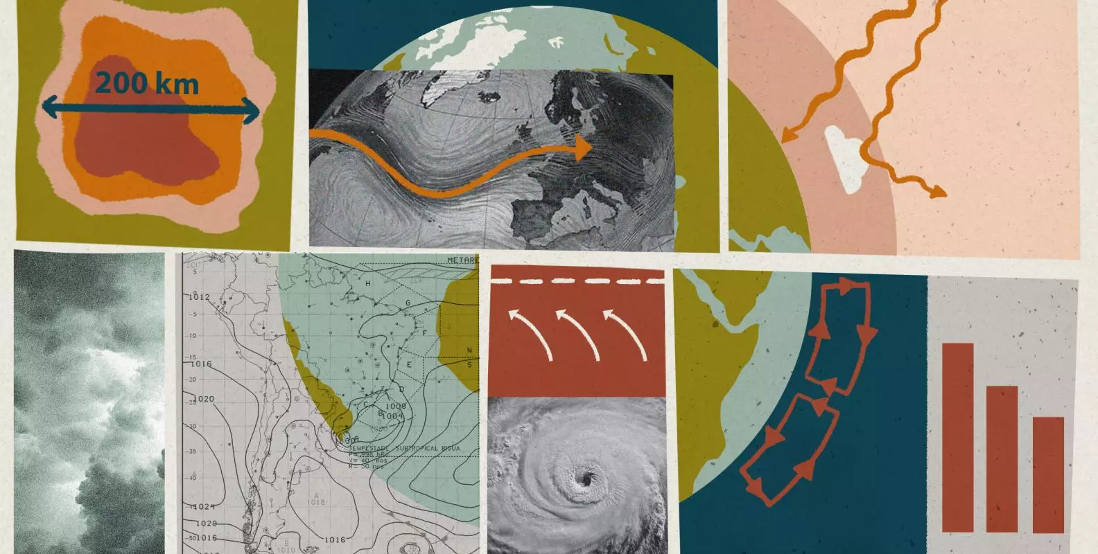
Convective vs stratiform (anvil) heating: the stratiform heating above 5 km is caused by the anvil cloud. The peak from the anvil heating is at about 8 km, higher than the peak from the convective (i.e. thunderstorm) heating. The anvil cloud produces rain; below 5 km, some of this rain evaporates as it falls towards the ground, cooling the surrounding air. From Houze 2004: https://doi.org/10.1029/2004RG000150.
What releases more energy than a single thunderstorm? A collection of them packed closely together. Under the right conditions, thunderstorms tend to form close to each other, producing large systems called MCSs. Alas, this does not stand for Mega Convective Storm, but instead the more prosaic Mesoscale Convective System - a collection of thunderstorms that affect winds and clouds over the mesoscale, or 100s of kilometres. All of these thunderstorms can produce a lot of anvil cloud, so much so that these clouds can easily cover 40,000 square kilometres - that’s about twice the size of Wales. So how can MCSs 1000s of miles away affect your weather?

3D structure of a Mesoscale Convective System over Oklahoma, observed by a radar onboard the GPM satellite. The dark red colours in the vertical cross section show high radar reflectivity - these are the convective regions where there are lots of raindrops. The entire MCS was about 900 kilometres across. Image credit: NASA / Hal Pierce: https://gpm.nasa.gov/extreme-weather/oklahoma-mesoscale-convective-system-mcs-examined-gpm.
The Jet Stream
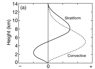
The final piece of the puzzle is the jet stream. This is a band of wind high up in the atmosphere - at about the same level as the top of thunderstorms and the anvil clouds. It travels west to east across the Atlantic. The location of the jet stream has a big impact on the weather in the UK - if it’s to the south of the UK, we are likely to have cold, polar air and storms battering our shores. If it’s north, then we will likely be sitting in balmy tropical air under clearer, sunnier skies. MCSs release their huge amounts of energy near the height of the jet stream. This drives a powerful outflow of wind that can disturb the high-level winds, creating a north-to-south wave in the jet stream. This wave can travel over the Atlantic to the UK, taking about a week to get here. So an MCS over the USA can lead to changes in weather over the UK, and if we don’t correctly represent the MCS over the USA in our forecast, then we might get a forecast bust over the UK a week later.
The jet stream high in the atmosphere (the tropopause), shown as white wind arrows, with the hot, tropical air mass to the south and the cold, polar air mass to the north. Waves on the jet stream appear as north-south meanders of the wind band. Source: Met Office. Contains public sector information licensed under the Open Government Licence v3.0.
From physics theory to real-world impacts
To recap, the chain of reasoning goes like this:
1. an MCS forms over the USA;
2. it releases heat high up;
3. this causes a wave in the jet stream;
4. the wave moves across the Atlantic and reaches the UK in about a week.
A bust could happen if we get any of these steps wrong in our forecast models. In our research project, called MCS:PRIME, we wanted to focus on the second step. What if MCSs in the forecast model release their energy in the wrong place or with the wrong timing? We studied this by detecting thunderstorms in our model and using a combination of observational data and theoretical insights to characterise the anvil heating that could be associated with them.
We then modified the high-level heating in the model, and made new forecasts with the improved model. We find that we still get busts, so we haven’t completely fixed the problem, but the size of the busts decreased - so we have improved the situation. This, combined with our solid chain of reasoning for the busts, gives us confidence that we are approaching this problem from the right direction.
So remember, when you look at the forecast for the week ahead on your phone, you are looking at the result of centuries of science and of billions of calculations that capture the chaotic motions of our atmosphere. The foundational science is well known. But there are still places where we can improve our forecasts, and reduce the number of forecast busts, ensuring that we can protect our energy grid and your weekend plans. This could be done by using AI in forecasts, or improving how we translate the laws of physics into code for our supercomputers. It might be that the next breakthrough is one that you could make.
Could this be you?
The MCS:PRIME project was carried out by scientists at the University of Oxford, the University of Reading, and the UK Met Office. Both universities are looking for engaged students who would like to learn more about our chaotic atmosphere, and might like to work on these sorts of problems in the future. If you enjoyed reading this article, research in this area could be for you.